The Station Fire in San Gabriel
Mountains in late 2009 was the largest wildfire in the area in on record.[1] The fire spread over an area of 251 square
miles just north of the San Fernando Valley communities of La Cañada
Flintridge and Glendale. It lasted for
21 days, destroyed 89 homes and killed two firefighters. Of course, the fire did not begin instantly. Rather, it started off small before it spread
Northward and Eastward across the San Gabriel Mountains. By examining the features of the land that
supported the fire, one can gain insight into what geographical factors
encourage fires to spread and what methodologies firefighters can and do use to
contain the spread. The below maps
provide information for the analysis of why the Station Fire spread in the
directions and to the extent that it did.
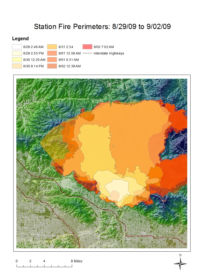
The reference map of the Station
Fire Perimeters highlights the peculiar spread of the fire. It shows that the fire spread northwest,
along the ridge of the mountains against the valley. Once it reached a certain latitude, it began
to spread West and East, though it mostly spread East. Eventually, it was contained in a circular
region solely within the mountain range.
The fire reached the fringes of the populated valley, but never more
than the very edge.
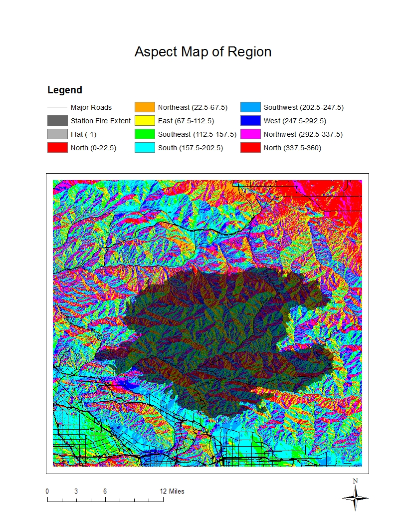
The reference map and the Aspect Map
explain some of the reasons why the fire spread in these directions. The mountains on the East edge of the extended
fire are relatively high in altitude, and thus provide a natural barrier to the
continued spread of the fire. In
addition, this part of the mountain range has an aspect that predominantly
points west, meaning that the fire would have to spread uphill in order to
continue east. High altitudes appear to quell the spread of a wildfire.
However, slope and aspect seem to be irrelevant to the pattern of the fire in every other direction, as
evidenced by the fact that the fire did not spread into the valley, a region
both lower in elevation and with an aspect that points south towards it. In this latter case, it was likely the
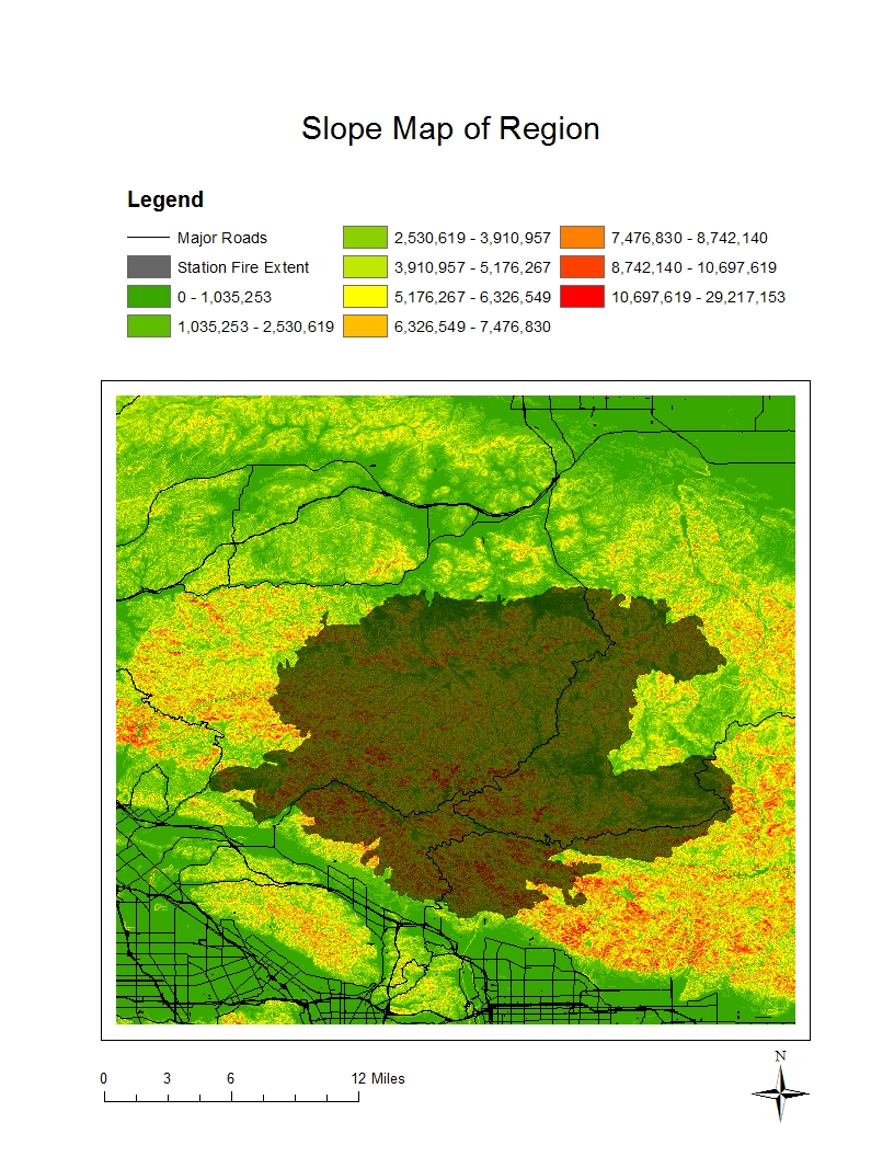
firefighters, and not the topography, that dictated the movements of the fire. In addition, the Slope Map indicates little
to no correlation between the ability of the fire to spread and the local topography. The fire spread mostly over land with steep slopes. This pattern was likely due to the fact that
the more mountainous terrain was undeveloped and covered in trees than that it
was sloped.
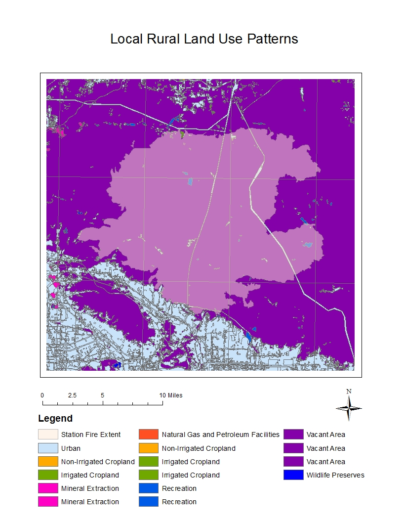
The reference map and the Land Use
Patterns Map illustrate the success of the efforts of the firefighters to stop
the fire from damaging populated communities.
The fire began very near the populated valley, and initially spread in
all directions—including south. But
quickly, and despite the area’s south-facing aspect, the fire was re-routed to
spread along the mountain ridge. Because
the fire so clearly avoided any populated areas, it appears that human efforts
were able to control its path.
The crew deliberately attempted to
stop the fire from spreading across a populated region, as they were likely only
able to stop its spread in one direction.
As the fire moved northwest, it once again began to reach homes, this
time on its western edge. And this time,
the fire crew was able to stop its western spread. By containing the fire on one side at a time,
the crew ensured that the fire consumed land labeled by the US government as “Vacant
Area.” Ultimately, it was the
firefighters, and not the topography, that dictated the spread of the Station
Fire.
[1] Bloomekatz, Ari. “Station fire is largest in L.A. County's modern history.” Los Angeles Times 2 Sep. 2009. <http://latimesblogs.latimes.com/lanow/2009/09/station-fire-is-largest-in-la-county-history.html>


Bibliography:
Los Angeles County Enterprise. “All Station Fire Perimeters.” 2 Sep. 2009. <http://egis3.lacounty.gov/eGIS/2009/09/02/all-station-fire-perimiters-as-of-september-2-0702-complete-ste/>
USGS Seamless Data Warehouse. “The National Map Seamless Server.” United States Geological Survey.
<http://seamless.usgs.gov/website/seamless/viewer.htm>
UCLA Mapshare. “Los Angeles County Major Roads,” “Los Angeles County Local Streets,” “Los Angeles Interstate Highways,” and “2000 Land Use, Los Angeles County.” University of California, Los Angles. <http://gis.ats.ucla.edu//Mapshare/Default.cfm>
Bloomekatz, Ari. “Station fire is largest in L.A. County's modern history.” Los Angeles Times 2 Sep. 2009. <http://latimesblogs.latimes.com/lanow/2009/09/station-fire-is-largest-in-la-county-history.html>
Skelton, George. “State
help for firefighters ‘a heavy lift.’” Capitol Journal 10 Sept. 2009. <http://www.latimes.com/news/local/la-me-cap10-2009sep10,0,4019331.column>
No comments:
Post a Comment